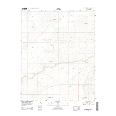
2014 Map of Dipping Water Well
USGS Topo · Published 2014About this map
Wide Ruin Wash defines the drainage patterns of this high desert terrain in the Fort Defiance Agency region. This 2014 survey captures a landscape structured by mesa formations and remote access routes, most notably the eponymous Dipping Water Well located near the northern reaches of the wash. The area is characterized by seasonal watercourses like Dead Wash, which cuts through the southern sections of the township grid. Dominant landforms such as Padres Mesa rise above the surrounding flats, while transit is limited to a handful of designated corridors including Blue Metal Rd and Lapinta Mesa Rd. These roads provide the primary links through this part of the Navajo Nation, following the natural contours of the mesas and washes that dictate movement across the arid environment.
Find a feature on this map
13 named features on this map. Tap any name to fly to it.
Don’t see what you’re looking for? This feature index may not catch every label — zoom into the map to look around manually.
Map Details
Editions of this 2014 Dipping Water Well Map
This is the sole edition of this map. No revisions or reprints were ever made.
Other maps of this area

1886 · Fort Defiance
USGS Topo · 1:250,000

1892 · Fort Defiance
USGS Topo · 1:250,000

1954 · Gallup
USGS Topo · 1:250,000

1958 · Gallup
USGS Topo · 1:250,000

1959 · Gallup
USGS Topo · 1:250,000

1962 · Gallup
USGS Topo · 1:250,000

1967 · Gallup
USGS Topo · 1:250,000

1971 · Wide Ruins
USGS Topo · 1:24,000
1971 · Chambers
USGS Topo · 1:24,000
1971 · Wide Ruins SW
USGS Topo · 1:24,000