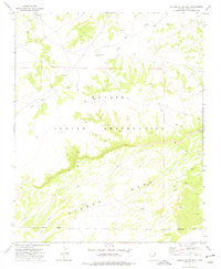
1972 Map of Dipping Water Well
USGS Topo · Published 1977About this map
Padres Mesa dominates the southern portion of this high desert landscape, providing a dramatic backdrop for the scattered watering points essential to life on the Navajo Indian Reservation. This 1970s survey illustrates a remote corner of Apache County where survival and settlement are closely tied to the drainage of Wide Ruin Wash and Dead Indian Wash. Sparse human presence is marked primarily by isolated landmarks such as John Joe Well and Dipping Water Well, reflecting the long-standing importance of reliable water sources in this arid territory. The map details the local infrastructure of the era, from unimproved roads to the occasional Water Tank, set against a terrain of plateaus and ephemeral washes.
Find a feature on this map
11 named features on this map. Tap any name to fly to it.
Don’t see what you’re looking for? This feature index may not catch every label — zoom into the map to look around manually.
Map Details
Editions of this 1972 Dipping Water Well Map
This is the sole edition of this map. No revisions or reprints were ever made.
Other maps of this area

1886 · Fort Defiance
USGS Topo · 1:250,000

1892 · Fort Defiance
USGS Topo · 1:250,000

1954 · Gallup
USGS Topo · 1:250,000

1958 · Gallup
USGS Topo · 1:250,000

1959 · Gallup
USGS Topo · 1:250,000

1962 · Gallup
USGS Topo · 1:250,000

1967 · Gallup
USGS Topo · 1:250,000

1971 · Wide Ruins
USGS Topo · 1:24,000
1971 · Chambers
USGS Topo · 1:24,000
1971 · Wide Ruins SW
USGS Topo · 1:24,000