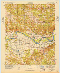
1949 Map of Direct
USGS Topo · Published 1949About this map
The Red River creates a meandering border between Oklahoma and Texas, defining the social and economic geography of this territory in the late 1940s. On the Oklahoma side, the townships of Bennington and Hunter are dotted with small educational and religious centers such as Iron Stob School, Crowder Prairie School, and Good Springs Church. The landscape is etched by drainage systems like Whitegrass Creek and Lick Creek, which flow toward the river valley. South of the river in Fannin and Lamar Counties, Texas, the terrain transitions into the dense creek networks of Bois d'Arc Creek and Sanders Creek. Small agrarian settlements like Monkstown, Riverby, and Direct serve as local hubs, while several burial grounds, including Forest Grove Cem and Arch Chapel Cem, offer critical data points for genealogical research into the region's early families.
Find a feature on this map
64 named features on this map. Tap any name to fly to it.
Don’t see what you’re looking for? This feature index may not catch every label — zoom into the map to look around manually.
Map Details
Editions of this 1949 Direct Map
2 editions found

Other maps of this area

1899 · Atoka
USGS Topo · 1:125,000

1900 · Atoka
USGS Topo · 1:125,000

1901 · Antlers
USGS Topo · 1:125,000

1903 · Paris
USGS Topo · 1:125,000

1912 · Antlers
USGS Topo · 1:125,000

1925 · Antlers
USGS Topo · 1:125,000

1947 · Honey Grove
USGS Topo · 1:62,500

1948 · Grant
USGS Topo · 1:62,500

1948 · Paris
USGS Topo · 1:62,500

1948 · Direct
USGS Topo · 1:62,500