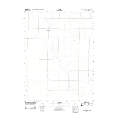
2011 Map of Dittons Creek NW
USGS Topo · Published 2011About this map
Stinking Water Creek meanders through this portion of Chase County, defining the drainage patterns of an otherwise orderly agricultural grid. The landscape is structured by a network of sectional roads, including 750 Rd and 342 Ave, which facilitate the movement of grain and livestock across the plains. A notable local landmark, the Stinking Water Creek Airport, sits in the northern section of the quadrangle, serving the aerial needs of this rural Nebraska community. The map illustrates the 2011 state of land use in the region, where the natural course of the creek creates the only deviation from the straight-line geometry of the county road system, such as 748 Rd and 344 Ave.
Find a feature on this map
15 named features on this map. Tap any name to fly to it.
Don’t see what you’re looking for? This feature index may not catch every label — zoom into the map to look around manually.
Map Details
Editions of this 2011 Dittons Creek NW Map
This is the sole edition of this map. No revisions or reprints were ever made.
Other maps of this area

1954 · McCook
USGS Topo · 1:250,000

1957 · McCook
USGS Topo · 1:250,000

1958 · McCook
USGS Topo · 1:250,000
1973 · Grainton
USGS Topo · 1:24,000

1973 · Imperial NE
USGS Topo · 1:24,000

1973 · Dittons Creek NE
USGS Topo · 1:24,000

1973 · Dittons Creek NW
USGS Topo · 1:24,000
1973 · Elsie
USGS Topo · 1:24,000

1973 · Imperial Municipal Airport
USGS Topo · 1:24,000
1973 · Madrid
USGS Topo · 1:24,000