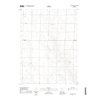
2017 Map of Dittons Creek NW
USGS Topo · Published 2017About this map
Stinking Water Cr meanders southward through the agricultural high plains of Southwest Nebraska, carving a distinct drainage through the section lines of Chase and Perkins counties. This 2017 survey shows the enduring grid of the Public Land Survey System, where townships like t9n r36w and t8n r37w dictate the placement of rural infrastructure. The landscape is defined by the incision of Cliff Dwellers Canyon in the southeast, a sharp topographical break from the surrounding plateau. A meticulous network of county roads, including 750 Rd and 342 Ave, provides access to the remote sections and farmsteads. The transition across the Perkins Co Chase Co boundary illustrates the administrative divisions that have organized this part of the Great Plains for generations, maintaining a landscape focused on ranching and dryland farming.
Find a feature on this map
23 named features on this map. Tap any name to fly to it.
Don’t see what you’re looking for? This feature index may not catch every label — zoom into the map to look around manually.
Map Details
Editions of this 2017 Dittons Creek NW Map
This is the sole edition of this map. No revisions or reprints were ever made.
Other maps of this area

1954 · McCook
USGS Topo · 1:250,000

1957 · McCook
USGS Topo · 1:250,000

1958 · McCook
USGS Topo · 1:250,000
1973 · Grainton
USGS Topo · 1:24,000

1973 · Imperial NE
USGS Topo · 1:24,000

1973 · Dittons Creek NE
USGS Topo · 1:24,000

1973 · Dittons Creek NW
USGS Topo · 1:24,000
1973 · Elsie
USGS Topo · 1:24,000

1973 · Imperial Municipal Airport
USGS Topo · 1:24,000
1973 · Madrid
USGS Topo · 1:24,000