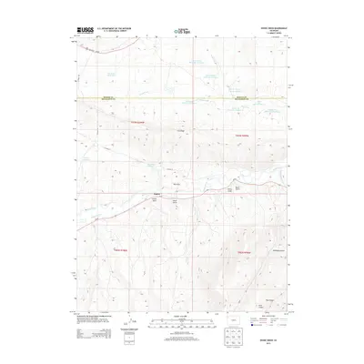
2013 Map of Divide Creek
USGS Topo · Published 2013About this map
Angora sits at the base of School Gulch in this high-altitude landscape along the border of Moffat and Rio Blanco counties. The area is defined by a sophisticated network of water management, evidenced by the numerous catchment basins such as Lower Wolf Cr Reservoir Number 1 and Divide Cr Reservoir Number 5. These structures, along with the Hammond Ditch, support life and industry across the arid terrain of Coal Ridge and Hall Draw. The White River meanders through the central valley, joined by tributaries like Little Spring Creek and Boise Creek. Local transportation follows the contours of the land via Co-64 and several county roads, providing access to the various gulches and canyons, including Alkali Gulch and Monument Gulch, which carve through the plateau.
Find a feature on this map
36 named features on this map. Tap any name to fly to it.
Don’t see what you’re looking for? This feature index may not catch every label — zoom into the map to look around manually.
Map Details
Editions of this 2013 Divide Creek Map
This is the sole edition of this map. No revisions or reprints were ever made.
Other maps of this area

1907 · Rangely
USGS Topo · 1:125,000

1907 · White River
USGS Topo · 1:125,000

1910 · White River
USGS Topo · 1:125,000

1910 · Rangely
USGS Topo · 1:125,000

1954 · Vernal
USGS Topo · 1:250,000

1958 · Vernal
USGS Topo · 1:250,000

1960 · Vernal
USGS Topo · 1:250,000

1960 · Elk Springs
USGS Topo · 1:62,500

1962 · Cactus Reservoir
USGS Topo · 1:24,000
1962 · Calamity Ridge
USGS Topo · 1:24,000