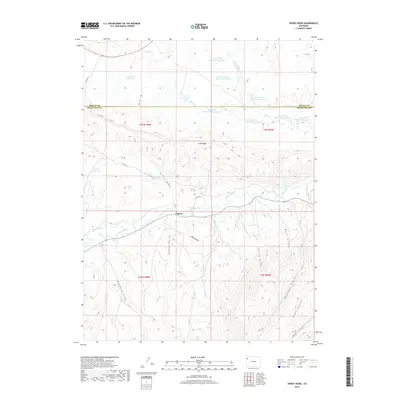
2019 Map of Divide Creek
USGS Topo · Published 2019About this map
White River valley ranching and water management define this portion of Rio Blanco County, where the settlement of Angora sits at the junction of several drainage systems. The landscape is heavily marked by early 21st-century water infrastructure, including the Hammond Ditch and numerous upland water storage sites such as Box Elder Reservoir and the series of numbered reservoirs along Wolf Cr. To the south, the terrain rises significantly toward Coal Ridge, a prominent landform dissected by deep drainage features like School Gulch and Alkali Gulch. This 2019 survey documents the complex network of draws and canyons, including Monument Gulch and Short Canyon, which illustrate the erosion patterns of the high desert plateau. The map details the border with Moffat County to the north and the specialized land use required to sustain agriculture in this arid environment through carefully placed features like Hall Draw Reservoir.
Find a feature on this map
35 named features on this map. Tap any name to fly to it.
Don’t see what you’re looking for? This feature index may not catch every label — zoom into the map to look around manually.
Map Details
Editions of this 2019 Divide Creek Map
This is the sole edition of this map. No revisions or reprints were ever made.
Other maps of this area

1907 · Rangely
USGS Topo · 1:125,000

1907 · White River
USGS Topo · 1:125,000

1910 · White River
USGS Topo · 1:125,000

1910 · Rangely
USGS Topo · 1:125,000

1954 · Vernal
USGS Topo · 1:250,000

1958 · Vernal
USGS Topo · 1:250,000

1960 · Vernal
USGS Topo · 1:250,000

1960 · Elk Springs
USGS Topo · 1:62,500

1962 · Cactus Reservoir
USGS Topo · 1:24,000
1962 · Calamity Ridge
USGS Topo · 1:24,000