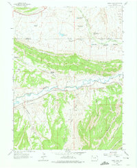
1962 Map of Divide Creek
USGS Topo · Published 1974About this map
Angora sits at a bend of the White River in the early 1960s, serving as a primary point of reference in this high-altitude landscape. The area is defined by a complex system of water management and topography, where the prominent Coal Ridge divides the river valley from a series of northern drainages. Numerous man-made water features dot the terrain, including Box Elder Reservoir, Villard Flats Reservoir, and Bobcat Reservoir, alongside a network of reservoirs serving Wolf Creek and Divide Creek. These catchments, such as Divide Creek Res No 5, suggest a landscape adapted for livestock or local resource extraction. To the south, deep incisions like Boise Gulch and Monument Gulch carve into the high country, while a Pipeline and scattered Jeep Trails provide the only industrial and transportation infrastructure through this sparsely populated boundary between Moffat and Rio Blanco counties.
Find a feature on this map
33 named features on this map. Tap any name to fly to it.
Don’t see what you’re looking for? This feature index may not catch every label — zoom into the map to look around manually.
Map Details
Editions of this 1962 Divide Creek Map
2 editions found
Other maps of this area

1907 · Rangely
USGS Topo · 1:125,000

1907 · White River
USGS Topo · 1:125,000

1910 · White River
USGS Topo · 1:125,000

1910 · Rangely
USGS Topo · 1:125,000

1954 · Vernal
USGS Topo · 1:250,000

1958 · Vernal
USGS Topo · 1:250,000

1960 · Vernal
USGS Topo · 1:250,000

1960 · Elk Springs
USGS Topo · 1:62,500

1962 · Cactus Reservoir
USGS Topo · 1:24,000
1962 · Calamity Ridge
USGS Topo · 1:24,000