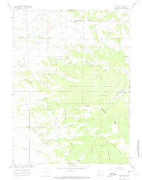
1961 Map of Divide Peak
USGS Topo · Published 1974About this map
The Continental Divide defines the hydrological and topographic character of this high-elevation landscape within the Medicine Bow National Forest. In the early 1960s, this area of Carbon County remained largely defined by its natural drainage systems, such as the North Fork Savery Creek and Mexican Creek, which carve through the high ridges. Human activity is sparse but telling, centered on resource extraction and seasonal ranching. The presence of the Bridger Mine and various Prospect markings indicate the mining interests that historically drove exploration in these mountains. Small outpost locations like the Hansen Ranch and the named landing at Twin Groves provide specific points of interest for genealogists tracing families who worked this high country. Peaks like Divide Peak and Dexter Peak serve as primary landmarks for navigating the complex network of creeks and gulches.
Find a feature on this map
32 named features on this map. Tap any name to fly to it.
Don’t see what you’re looking for? This feature index may not catch every label — zoom into the map to look around manually.
Map Details
Editions of this 1961 Divide Peak Map
4 editions found
Other maps of this area

1932 · Savery
USGS Topo · 1:96,000

1940 · Savery
USGS Topo · 1:125,000

1954 · Rawlins
USGS Topo · 1:250,000

1958 · Rawlins
USGS Topo · 1:250,000

1961 · Divide Peak
USGS Topo · 1:24,000

1961 · Middlewood Hill
USGS Topo · 1:24,000

1961 · Pine Grove Ranch
USGS Topo · 1:24,000

1961 · Bridger Peak
USGS Topo · 1:24,000

1961 · Jack Creek Reservoir
USGS Topo · 1:24,000
1961 · Singer Peak
USGS Topo · 1:24,000