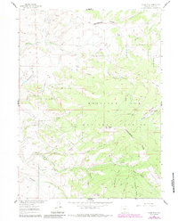
1961 Map of Divide Peak
USGS Topo · Published 1984About this map
The Continental Divide winds through the high country of the Medicine Bow National Forest on this 1961 survey, updated for 1983. This high-altitude drainage basin is defined by the headwaters of the North Fork Savery Creek and East Fork Savery Creek, where several small-scale resource extractions are documented. These include the Bridger Mine and various prospect pits scattered across the slopes near Mc Lain Creek. Human activity is concentrated along the creek bottoms, evidenced by the Hansen Ranch and the isolated Twin Groves. The terrain is deeply incised by family-named and descriptively named drainages such as Hartt Creek, Hatch Creek, and the uniquely titled Dirty Man Fork and Truckdrivers Creek. Dominating the skyline are prominent summits like Divide Peak and Dexter Peak, marking the crest of the divide in a landscape primarily utilized for ranching and mineral exploration within the national forest boundary.
Find a feature on this map
26 named features on this map. Tap any name to fly to it.
Don’t see what you’re looking for? This feature index may not catch every label — zoom into the map to look around manually.
Map Details
Editions of this 1961 Divide Peak Map
4 editions found
Other maps of this area

1932 · Savery
USGS Topo · 1:96,000

1940 · Savery
USGS Topo · 1:125,000

1954 · Rawlins
USGS Topo · 1:250,000

1958 · Rawlins
USGS Topo · 1:250,000

1961 · Divide Peak
USGS Topo · 1:24,000

1961 · Middlewood Hill
USGS Topo · 1:24,000

1961 · Pine Grove Ranch
USGS Topo · 1:24,000

1961 · Bridger Peak
USGS Topo · 1:24,000

1961 · Jack Creek Reservoir
USGS Topo · 1:24,000
1961 · Singer Peak
USGS Topo · 1:24,000