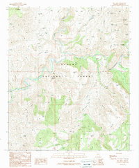
1989 Map of Dix Creek
USGS Topo · Published 1990About this map
The San Francisco River cuts a deep, winding path through this portion of the Apache National Forest, meeting the Blue River in a landscape defined by dramatic elevation changes. The presence of the Martinez Ranch near the confluence of Dix Creek highlights the sparse but persistent human footprint in this remote Arizona territory. Much of the water management on this high desert terrain is focused on stock tanks and springs, such as Red Tank Well, Snake Ridge Tank, and the notably named Blue Holes Spring. The topography is characterized by flat-topped features like Antelope Mesa and Hickey Mesa, which are separated by steep drainages including Lightning Canyon and Sixshooter Canyon. This 1989 provisional survey captures the transition from high mesas to river bottoms before modern development, preserving the locations of remote line shacks and seasonal water sources essential for cattle ranching.
Find a feature on this map
83 named features on this map. Tap any name to fly to it.
Don’t see what you’re looking for? This feature index may not catch every label — zoom into the map to look around manually.
Map Details
Editions of this 1989 Dix Creek Map
This is the sole edition of this map. No revisions or reprints were ever made.
Other maps of this area

1902 · Clifton
USGS Topo · 1:62,500

1913 · Morenci
USGS Topo · 1:125,000

1915 · Morenci
USGS Topo · 1:125,000

1954 · Clifton
USGS Topo · 1:250,000

1957 · Clifton
USGS Topo · 1:250,000

1958 · Clifton
USGS Topo · 1:250,000

1962 · Clifton
USGS Topo · 1:250,000

1962 · Clifton
USGS Topo · 1:62,500

1962 · Big Lue Mts
USGS Topo · 1:62,500
1967 · Pipestem Mtn
USGS Topo · 1:24,000