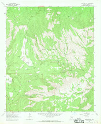
1967 Map of Pipestem Mtn
USGS Topo · Published 1970About this map
The Apache National Forest dominates this landscape in Greenlee County, where the topography is defined by high plateaus and deep drainage networks. The prominent Four Bar Mesa and No Bar Mesa provide level ground above the steep cuts of Juan Miller Creek and Pigeon Creek. This area, surveyed in the mid-1960s, reveals a remote backcountry managed for both recreation and cattle ranching.
Find a feature on this map
41 named features on this map. Tap any name to fly to it.
Don’t see what you’re looking for? This feature index may not catch every label — zoom into the map to look around manually.
Map Details
Editions of this 1967 Pipestem Mtn Map
3 editions found
Other maps of this area

1902 · Clifton
USGS Topo · 1:62,500

1913 · Morenci
USGS Topo · 1:125,000

1915 · Morenci
USGS Topo · 1:125,000

1954 · Clifton
USGS Topo · 1:250,000

1957 · Clifton
USGS Topo · 1:250,000

1958 · Clifton
USGS Topo · 1:250,000

1962 · Clifton
USGS Topo · 1:250,000

1962 · Clifton
USGS Topo · 1:62,500

1962 · Big Lue Mts
USGS Topo · 1:62,500

1967 · Robinson Mesa
USGS Topo · 1:24,000