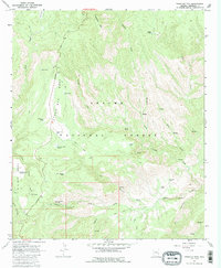
1967 Map of Pipestem Mountain
USGS Topo · Published 1985About this map
Coronado Trail winds through the high mesas and deep canyons of the Apache National Forest in this late 1960s survey. The landscape is defined by its water management infrastructure for high-altitude ranching, featuring a network of livestock tanks such as Filleman Tank, Joe Tank, and the Four Bar Mesa Tanks. The topography transitions from the heights of Pipestem Mtn and Four Bar Mesa down into the drainage systems of Juan Miller Creek and Pigeon Creek. Recreational and remote living sites are noted at the Lower Juan Miller Campground, the Upper Juan Miller Picnic Area, and the isolated Trail Cabin. This map provides a detailed view of the remote cattle-grazing and forest-service activities in Greenlee County before the era of modern development, including specialized labels like the CCC Tank which hints at the region's earlier conservation labor history.
Find a feature on this map
42 named features on this map. Tap any name to fly to it.
Don’t see what you’re looking for? This feature index may not catch every label — zoom into the map to look around manually.
Map Details
Editions of this 1967 Pipestem Mountain Map
3 editions found
Other maps of this area

1902 · Clifton
USGS Topo · 1:62,500

1913 · Morenci
USGS Topo · 1:125,000

1915 · Morenci
USGS Topo · 1:125,000

1954 · Clifton
USGS Topo · 1:250,000

1957 · Clifton
USGS Topo · 1:250,000

1958 · Clifton
USGS Topo · 1:250,000

1962 · Clifton
USGS Topo · 1:250,000

1962 · Clifton
USGS Topo · 1:62,500

1962 · Big Lue Mts
USGS Topo · 1:62,500

1967 · Robinson Mesa
USGS Topo · 1:24,000