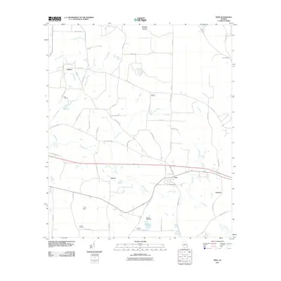
2011 Map of Dixie
USGS Topo · Published 2011About this map
Piscola Creek and its many tributaries, including Carroll Branch and Allen Branch, define the low-lying hydrology of Brooks County. This landscape is marked by a distinctive network of family and rural cemeteries such as Ozell Cemetery, Robinson Cemetery, and Groover Cemetery, providing significant anchor points for local genealogical research. The primary settlement at Dixie is supported by the Dixie Post Office, while the surrounding rural area is dotted with smaller communities like Pidcock, Oaklawn, and Emerson.
Find a feature on this map
59 named features on this map. Tap any name to fly to it.
Don’t see what you’re looking for? This feature index may not catch every label — zoom into the map to look around manually.
Map Details
Editions of this 2011 Dixie Map
This is the sole edition of this map. No revisions or reprints were ever made.
Other maps of this area

1954 · Valdosta
USGS Topo · 1:250,000

1956 · Grooverville
USGS Topo · 1:24,000

1956 · Monticello NE
USGS Topo · 1:24,000

1956 · Baden
USGS Topo · 1:24,000

1957 · Thomasville
USGS Topo · 1:62,500

1958 · Valdosta
USGS Topo · 1:250,000

1959 · Valdosta
USGS Topo · 1:250,000

1961 · Quitman
USGS Topo · 1:62,500
1974 · Quitman
USGS Topo · 1:24,000
1975 · Pebble Hill
USGS Topo · 1:24,000