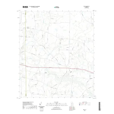
2020 Map of Dixie
USGS Topo · Published 2020About this map
Dixie serves as the central hub of this South Georgia landscape, situated along the CSX Transportation railroad and the Thomasville Rd corridor. The geography is defined by a complex network of intermittent water bodies and unusual karst-like depressions, most notably The Sinks and the seasonal basin of Dry Lake. Small agrarian settlements like Pidcock and Oaklawn are connected by a dense web of local roads, many bearing family names that reflect the area's genealogical history, such as Coleman Rd, Simpson Rd, and Boles Rd. Numerous small burial grounds are scattered across the terrain, including Beasley Cem and Groover Cem, providing specific points of interest for researchers tracing local lineage. The drainage patterns of Piscola Creek and its various branches like Carroll Br and Pride Br weave through the fields, illustrating the hydraulic character of the Thomas and Brooks county line.
Find a feature on this map
87 named features on this map. Tap any name to fly to it.
Don’t see what you’re looking for? This feature index may not catch every label — zoom into the map to look around manually.
Map Details
Editions of this 2020 Dixie Map
This is the sole edition of this map. No revisions or reprints were ever made.
Other maps of this area

1954 · Valdosta
USGS Topo · 1:250,000

1956 · Grooverville
USGS Topo · 1:24,000

1956 · Monticello NE
USGS Topo · 1:24,000

1956 · Baden
USGS Topo · 1:24,000

1957 · Thomasville
USGS Topo · 1:62,500

1958 · Valdosta
USGS Topo · 1:250,000

1959 · Valdosta
USGS Topo · 1:250,000

1961 · Quitman
USGS Topo · 1:62,500
1974 · Quitman
USGS Topo · 1:24,000
1975 · Pebble Hill
USGS Topo · 1:24,000