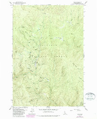
1979 Map of Dixie
USGS Topo · Published 1987About this map
Mining operations and remote settlements define this high-elevation landscape within the Nez Perce National Forest during the late 1970s and 1980s. The map centers on the historical activity around Dixie Mine, where a concentration of claims including the American Mine, Ajax Mine, and Dixie Queen Mine follow the drainages of Crooked Creek and Fourth of July Creek. Evidence of earlier settlement is found at Dixie House (Ruins) and the Midwayville (Site), reflecting the area's transition from active gold mining to a more secluded forest outpost supported by the Landing Strip and Dixie Woodyard. High ridges like Blue Ridge and peaks such as Burpee Mountain separate these drainages, while a network of Pack Trails and Jeep Trails provides the primary access to remote sites like the Black Diamond Mine and the nearby Cem.
Find a feature on this map
67 named features on this map. Tap any name to fly to it.
Don’t see what you’re looking for? This feature index may not catch every label — zoom into the map to look around manually.
Map Details
Editions of this 1979 Dixie Map
2 editions found
Other maps of this area

1931 · Buffalo Hump
USGS Topo · 1:125,000

1934 · Buffalo Hump
USGS Topo · 1:125,000

1956 · Warren
USGS Topo · 1:62,500

1956 · Elk City
USGS Topo · 1:250,000

1960 · Elk City
USGS Topo · 1:250,000

1977 · Silver Spur Ridge
USGS Topo · 1:24,000

1978 · Moose Butte
USGS Topo · 1:24,000

1978 · Trapper Creek
USGS Topo · 1:24,000
1979 · Orogrande
USGS Topo · 1:24,000

1979 · Dixie
USGS Topo · 1:24,000