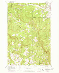
1961 Map of Dixie Mountain
USGS Topo · Published 1978About this map
Dixie Mtn rises as a central landmark in this 1961 survey, where the boundaries of Washington, Columbia, and Multnomah counties converge. The landscape is defined by a dense network of drainage systems, including Dutch Canyon, Wolf Creek, and McKay Creek, which carve through the upland terrain. Cultural markers of early settlement are visible in the clusters of community infrastructure, such as the Grange Hall and the Wallace Sch near the western slopes.
Find a feature on this map
47 named features on this map. Tap any name to fly to it.
Don’t see what you’re looking for? This feature index may not catch every label — zoom into the map to look around manually.
Map Details
Editions of this 1961 Dixie Mountain Map
4 editions found
Other maps of this area

1915 · Hillsboro
USGS Topo · 1:62,500

1918 · Hillsboro
USGS Topo · 1:62,500

1922 · St. Helens
USGS Topo · 1:62,500

1940 · Hillsboro
USGS Topo · 1:62,500

1940 · Vernonia
USGS Topo · 1:62,500

1941 · St Helens
USGS Topo · 1:62,500

1941 · Gales Creek
USGS Topo · 1:62,500

1943 · Vernonia
USGS Topo · 1:62,500

1943 · St Helens
USGS Topo · 1:62,500

1948 · Vancouver
USGS Topo · 1:250,000