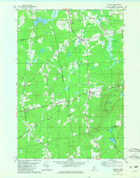
1982 Map of Dixmont
USGS Topo · Published 1982About this map
Mount Harris dominates the central landscape of this rural Maine quadrangle, featuring a Lookout Tower that surveys the surrounding townships of Dixmont, Troy, and Jackson. This 1982 edition illustrates a region defined by agricultural heritage and small-town crossroads, where settlements like Dixmont Center and North Dixmont cluster around intersections. The map is a vital resource for genealogical research, documenting several family-named burial grounds including Jewel Cem, Hathaway Cem, and Sawyer Cem. Waterways like Martin Stream and the North Branch Marsh Stream wind through the wooded lowlands, past landmarks such as Hows Corners and Rogers Corners. The presence of numerous Gravel Pit locations across the terrain reflects the local geology and the ongoing maintenance of the township's rural road network during the late twentieth century.
Find a feature on this map
38 named features on this map. Tap any name to fly to it.
Don’t see what you’re looking for? This feature index may not catch every label — zoom into the map to look around manually.
Map Details
Editions of this 1982 Dixmont Map
2 editions found
Other maps of this area

1926 · Burnham
USGS Topo · 1:62,500

1930 · Pittsfield
USGS Topo · 1:48,000

1931 · Stetson
USGS Topo · 1:48,000

1932 · Brooks
USGS Topo · 1:62,500

1932 · Pittsfield
USGS Topo · 1:62,500

1933 · Pittsfield
USGS Topo · 1:62,500

1935 · Stetson
USGS Topo · 1:62,500

1948 · Bangor
USGS Topo · 1:250,000

1955 · Pittsfield
USGS Topo · 1:62,500

1955 · Brooks
USGS Topo · 1:62,500