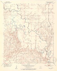
1952 Map of Doddridge NW
USGS Topo · Published 1953About this map
The Sulphur River meanders across the landscape of Miller County, shaping a complex network of wetlands and oxbows including Mercer Bayou, Little Pond, and Mercer Lake. In the early 1950s, this region was defined by its water and rail connections, with the Texas and Pacific railroad providing the primary industrial artery through the settlement at Ft Lynn. Local social life centered around rural congregations such as Antioch Ch, Springhill Ch, and Olive Branch Ch.
Find a feature on this map
25 named features on this map. Tap any name to fly to it.
Don’t see what you’re looking for? This feature index may not catch every label — zoom into the map to look around manually.
Map Details
Editions of this 1952 Doddridge NW Map
4 editions found
Other maps of this area

1907 · Atlanta
USGS Topo · 1:62,500

1909 · Texarkana
USGS Topo · 1:62,500

1910 · Atlanta
USGS Topo · 1:62,500

1952 · Doddridge SE
USGS Topo · 1:24,000

1952 · Doddridge NW
USGS Topo · 1:24,000

1952 · Doddridge
USGS Topo · 1:24,000

1952 · Fouke SE
USGS Topo · 1:24,000

1952 · Doddridge NE
USGS Topo · 1:24,000

1952 · Fouke
USGS Topo · 1:24,000

1953 · Texarkana
USGS Topo · 1:250,000