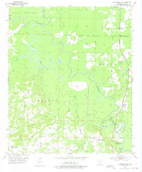
1952 Map of Doddridge NW
USGS Topo · Published 1975About this map
Sulphur River dominates this pocket of southwest Arkansas, winding through low-lying wetlands and bottomlands as they appeared in the early 1950s. The landscape is defined by its complex hydrology, where the meandering river meets Mercer Bayou and smaller bodies of water like Mercer Lake and Kennedy Lake. This river-dependent geography shaped local development, evidenced by the scattered communities and rural institutions like Ft Lynn and Black Diamond that relied on these waterways and the neighboring Texas and Pacific railroad for connectivity.
Find a feature on this map
26 named features on this map. Tap any name to fly to it.
Don’t see what you’re looking for? This feature index may not catch every label — zoom into the map to look around manually.
Map Details
Editions of this 1952 Doddridge NW Map
4 editions found
Other maps of this area

1907 · Atlanta
USGS Topo · 1:62,500

1909 · Texarkana
USGS Topo · 1:62,500

1910 · Atlanta
USGS Topo · 1:62,500

1952 · Doddridge SE
USGS Topo · 1:24,000

1952 · Doddridge NW
USGS Topo · 1:24,000

1952 · Doddridge
USGS Topo · 1:24,000

1952 · Fouke SE
USGS Topo · 1:24,000

1952 · Doddridge NE
USGS Topo · 1:24,000

1952 · Fouke
USGS Topo · 1:24,000

1953 · Texarkana
USGS Topo · 1:250,000