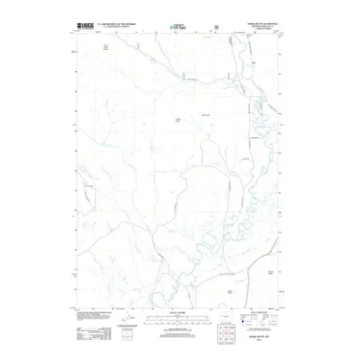
2012 Map of Dodge Butte
USGS Topo · Published 2012About this map
The Green River meanders through this high-altitude landscape in Sublette County, defining the drainage patterns for numerous seasonal and permanent waterways. Along its upper reaches, the Tie Camp Cem stands as a quiet marker of the region’s logging history, specifically the period when "tie hacks" harvested timber for railroad construction. The terrain is marked by prominent high points such as Dodge Butte, Black Butte, and White Point, which serve as visual anchors across the sagebrush and grazing lands. Ranching heritage is anchored by the Flying A Ranch, with access provided by a network of unimproved routes like White Point Rd and Sections Rd. A complex web of creeks, including Wagonfeur Cr, Badger Cr, and the converging Big Twin Cr and Little Twin Cr, provides a detailed look at the local hydrography that has sustained livestock and wildlife for generations.
Find a feature on this map
32 named features on this map. Tap any name to fly to it.
Don’t see what you’re looking for? This feature index may not catch every label — zoom into the map to look around manually.
Map Details
Editions of this 2012 Dodge Butte Map
This is the sole edition of this map. No revisions or reprints were ever made.
Other maps of this area

1907 · Gros Ventre
USGS Topo · 1:125,000

1909 · Fremont Peak
USGS Topo · 1:125,000

1910 · Gros Ventre
USGS Topo · 1:125,000

1955 · Driggs
USGS Topo · 1:250,000

1955 · Thermopolis
USGS Topo · 1:250,000

1958 · Driggs
USGS Topo · 1:250,000

1958 · Thermopolis
USGS Topo · 1:250,000

1962 · Thermopolis
USGS Topo · 1:250,000

1962 · Driggs
USGS Topo · 1:250,000
1966 · Warren Bridge
USGS Topo · 1:24,000