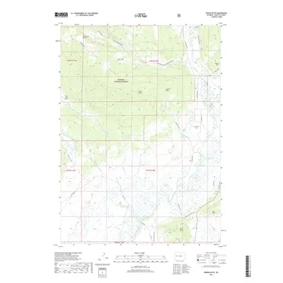
2017 Map of Dodge Butte
USGS Topo · Published 2017About this map
Bridger National Forest dominates this section of the Wyoming high country, where the Green River flows through a landscape defined by prominent ridges and isolated summits. The northern reaches include Tie Camp Cem, a quiet historical marker situated near the riverbanks. The terrain rises to notable peaks such as Dodge Butte, Black Butte, and the Rock Creek Buttes, reflecting the area's geological complexity. This portion of Sublette County is etched with an intricate network of drainage systems, including Whiskey Cr and Boulder Cr, alongside scattered meadows like Sawmill Park. Modern land use is indicated by a variety of local routes such as Black Butte Ranch Rd and Dodge Butte Rd, which provide access to remote areas like Twin Creek Basin and the high elevations of Gypsum Hill.
Find a feature on this map
45 named features on this map. Tap any name to fly to it.
Don’t see what you’re looking for? This feature index may not catch every label — zoom into the map to look around manually.
Map Details
Editions of this 2017 Dodge Butte Map
This is the sole edition of this map. No revisions or reprints were ever made.
Other maps of this area

1907 · Gros Ventre
USGS Topo · 1:125,000

1909 · Fremont Peak
USGS Topo · 1:125,000

1910 · Gros Ventre
USGS Topo · 1:125,000

1955 · Driggs
USGS Topo · 1:250,000

1955 · Thermopolis
USGS Topo · 1:250,000

1958 · Driggs
USGS Topo · 1:250,000

1958 · Thermopolis
USGS Topo · 1:250,000

1962 · Thermopolis
USGS Topo · 1:250,000

1962 · Driggs
USGS Topo · 1:250,000
1966 · Warren Bridge
USGS Topo · 1:24,000