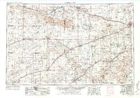
1955 Map of Dodge City
USGS Topo · Published 1976About this map
Arkansas River and Cimarron River valley life is captured here in the mid-1950s, illustrating the agricultural and transportation framework of Southwest Kansas and the Oklahoma panhandle. The map shows the established rail corridors of the Atchison Topeka and Santa Fe and the Chicago Rock Island and Pacific, which connect critical centers like Dodge City and Garden City. Outside these hubs, the landscape is defined by its water resources, including Lake McKinney and the North Fork Cimarron River. The inclusion of the Duranzo Trail offers a look at the historic transit routes that predated the modern grid. From the Sand hills to the many Gravel pits scattered across the plains, the map documents a region where industry and geography are deeply intertwined.
Find a feature on this map
77 named features on this map. Tap any name to fly to it.
Don’t see what you’re looking for? This feature index may not catch every label — zoom into the map to look around manually.
Map Details
Editions of this 1955 Dodge City Map
3 editions found

Other maps of this area

1890 · Granada
USGS Topo · 1:125,000

1891 · Albany
USGS Topo · 1:125,000

1891 · Larned
USGS Topo · 1:125,000

1892 · Ness
USGS Topo · 1:125,000

1892 · Meade
USGS Topo · 1:125,000

1892 · Dodge
USGS Topo · 1:125,000

1892 · Vilas
USGS Topo · 1:125,000

1892 · Granada
USGS Topo · 1:125,000

1892 · Spearville
USGS Topo · 1:125,000

1893 · Albany
USGS Topo · 1:125,000