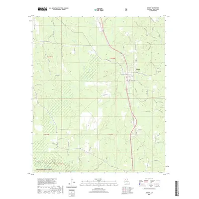
2020 Map of Dodson
USGS Topo · Published 2020About this map
The town of Dodson sits at a crossroads of early twentieth-century transport and modern forestry in northern Winn Parish. The landscape is defined by the complex drainage systems of the Dugdemona River basin, with numerous named waterways such as Antwine Cr, Caney Cr, and the low-lying Hogtail Slough shaping the local geography. A significant portion of the southwest is occupied by the Kisatchie National Forest, reflecting the area's long-standing reliance on timber resources. Traces of rural family history appear in road names like Roby Higgs Rd, Leonard Vines Rd, and Tony McKenzie Higgs, while the small settlement of Gresham and the Moffett Cem Rd provide specific points of interest for genealogists tracing local lineages. The network of parish roads and the path of the river underscore a settlement pattern closely tied to the creek bottoms and the pine forests of central Louisiana.
Find a feature on this map
83 named features on this map. Tap any name to fly to it.
Don’t see what you’re looking for? This feature index may not catch every label — zoom into the map to look around manually.
Map Details
Editions of this 2020 Dodson Map
This is the sole edition of this map. No revisions or reprints were ever made.
Other maps of this area

1947 · Goldonna
USGS Topo · 1:62,500

1949 · Calvin NE
USGS Topo · 1:31,680

1949 · Jonesboro
USGS Topo · 1:62,500

1950 · Jonesboro
USGS Topo · 1:62,500

1950 · Winnfield
USGS Topo · 1:62,500

1951 · Winnfield
USGS Topo · 1:62,500

1953 · Alexandria
USGS Topo · 1:250,000

1955 · Shreveport
USGS Topo · 1:250,000

1955 · Alexandria
USGS Topo · 1:250,000
1955 · Calvin
USGS Topo · 1:62,500