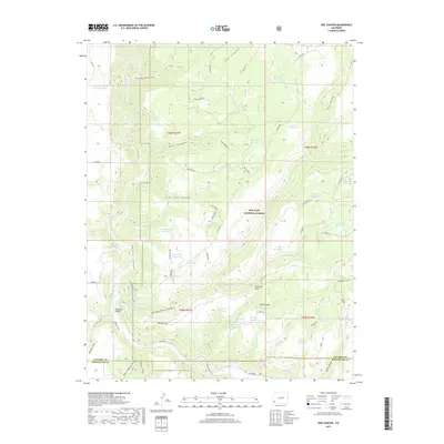
2019 Map of Doe Canyon
USGS Topo · Published 2019About this map
The Dolores River carves a path through the landscape of the San Juan National Forest in this southwestern Colorado survey. Water management is a central theme, evidenced by an extensive network of specialized catchments such as the Doe Reseeding Reservoir, Study Plot Reservoir, and the curiously named Rabit Hash Reservoir. The terrain is defined by deep incisions like Narraguinnep Canyon and Cow Canyon, which drain into the river valley. Human infrastructure in this high-country environment is represented by the Bradfield Bridge and a series of forest roads including Co RD R and Lone Dome F. The map also captures the local industrial footprint at the Gravel Pit Reservoir and the intersection of county lines at the boundary of Dolores and Montezuma counties.
Find a feature on this map
50 named features on this map. Tap any name to fly to it.
Don’t see what you’re looking for? This feature index may not catch every label — zoom into the map to look around manually.
Map Details
Editions of this 2019 Doe Canyon Map
This is the sole edition of this map. No revisions or reprints were ever made.
Other maps of this area

1956 · Cortez
USGS Topo · 1:250,000

1958 · Cortez
USGS Topo · 1:250,000

1959 · Cortez
USGS Topo · 1:250,000

1962 · Cortez
USGS Topo · 1:250,000

1964 · Glade Mountain
USGS Topo · 1:24,000
1964 · Secret Canyon
USGS Topo · 1:24,000

1964 · The Glade
USGS Topo · 1:24,000

1965 · Cahone
USGS Topo · 1:24,000

1965 · Yellow Jacket
USGS Topo · 1:24,000
1965 · Pleasant View
USGS Topo · 1:24,000