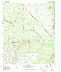
1972 Map of Dog Creek NE
USGS Topo · Published 1987About this map
The North Concho River winds through this rugged West Texas landscape where the boundaries of Coke, Sterling, and Tom Green counties converge. This 1972 survey, with later revisions, documents a region defined by its energy and ranching character. The map reveals the extensive industrial footprint of the Water Valley Oil Field, Clark Oil Field, and Hall Oil Field, marked by numerous Oil Wells and a major pipeline cutting diagonally across the terrain. Small-scale features such as a Gravel Pit and a lone Grave near the river provide specific points of interest for local historians and genealogists. Water remains central to the geography, with several drainage systems including Walnut Creek, Coyote Creek, and Mulberry Creek feeding into the main river channel.
Find a feature on this map
18 named features on this map. Tap any name to fly to it.
Don’t see what you’re looking for? This feature index may not catch every label — zoom into the map to look around manually.
Map Details
Editions of this 1972 Dog Creek NE Map
2 editions found
Other maps of this area

1954 · San Angelo
USGS Topo · 1:250,000

1957 · Carlsbad
USGS Topo · 1:62,500

1958 · San Angelo
USGS Topo · 1:250,000

1965 · San Angelo
USGS Topo · 1:250,000

1972 · Sterling City
USGS Topo · 1:24,000

1972 · Dog Creek NE
USGS Topo · 1:24,000

1972 · Dog Creek SW
USGS Topo · 1:24,000

1972 · Broome
USGS Topo · 1:24,000

1972 · Dog Creek NW
USGS Topo · 1:24,000
1972 · Dog Creek
USGS Topo · 1:24,000