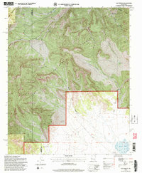
1995 Map of Dog Springs
USGS Topo · Published 1998About this map
Cibola National Forest encompasses the high country of the Datil Mountains and the Gallinas Mts in this high-altitude livestock and water-management landscape. The map reveals a complex network of canyons, including Dog Springs Canyon, Thompson Canyon, and Rock House Canyon, where terrain dictates the placement of essential water infrastructure. This late-twentieth-century revision, updated by the Forest Service, documents a geography of survival where remote wells and windmills serve as the primary landmarks. Family names and specific sites like the John Henry Windmill, Rincon Windmill, and Ramsey Windmill highlight the intersection of individual land use and public forest management. Toward the southern extent, the mountains give way to the plains near North Lake, marking a distinct shift from the steep canyon systems to more open cattle country along the Catron and Socorro County line.
Find a feature on this map
31 named features on this map. Tap any name to fly to it.
Don’t see what you’re looking for? This feature index may not catch every label — zoom into the map to look around manually.
Map Details
Editions of this 1995 Dog Springs Map
This is the sole edition of this map. No revisions or reprints were ever made.
Other maps of this area

1954 · Socorro
USGS Topo · 1:250,000

1958 · Socorro
USGS Topo · 1:250,000

1962 · Socorro
USGS Topo · 1:250,000

1963 · Cal Ship Mesa
USGS Topo · 1:24,000

1963 · Datil
USGS Topo · 1:24,000

1964 · Indian Mesa
USGS Topo · 1:24,000

1964 · Table Mountain
USGS Topo · 1:24,000

1964 · Dog Springs
USGS Topo · 1:24,000

1964 · Pasture Canyon
USGS Topo · 1:24,000

1964 · Lion Mountain
USGS Topo · 1:24,000