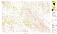
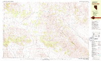
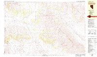
1979 Map of Dogskin Mtn
USGS Topo · Published 1979About this map
The Nevada-California state line bisects this 1970s survey, where the arid high desert is defined by a dense network of water sources and seasonal drainage. Numerous named springs like Sand Spring and Seale Springs suggest a landscape where water was the primary driver for both movement and early settlement. Central to the map, Dogskin Mountain rises above the Winnemucca Valley, which is traversed by the Winnemucca Ranch Road. Small-scale activity is evident in the presence of several Prospects and a Grave located near the ranch, pointing to a history of solitary labor and isolated homesteading in the shadow of the Virginia Mountains. The distribution of Benner Well and various ranch structures across Lees Flat reflects the importance of water management for livestock in the Red Rock Valley and Dry Valley corridors.
Find a feature on this map
36 named features on this map. Tap any name to fly to it.
Don’t see what you’re looking for? This feature index may not catch every label — zoom into the map to look around manually.
Map Details
Editions of this 1979 Dogskin Mtn Map
3 editions found
Other maps of this area

1886 · Honey Lake
USGS Topo · 1:250,000

1886 · Granite Range
USGS Topo · 1:250,000

1890 · Sierraville
USGS Topo · 1:125,000

1891 · Honey Lake
USGS Topo · 1:250,000

1891 · Reno
USGS Topo · 1:125,000

1892 · Sierraville
USGS Topo · 1:125,000

1893 · Honey Lake
USGS Topo · 1:250,000

1893 · Reno
USGS Topo · 1:125,000

1894 · Granite Range
USGS Topo · 1:250,000

1894 · Sierraville
USGS Topo · 1:125,000