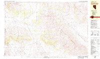
1979 Map of Dogskin Mtn
USGS Topo · Published 1979About this map
Dogskin Mountain dominates this late-1970s landscape on the California-Nevada border, where the Great Basin's high desert peaks meet wide, arid valleys. The area is defined by its water-scarce environment, evidenced by the numerous named water sources like Willow Spring, Lower Wildcat Spring, and Steele Springs that would have been vital for cattle and early travelers. Settlement is sparse, anchored by the Winnemucca Ranch in the Winnemucca Valley and the smaller outpost at Lees Flat.
Find a feature on this map
39 named features on this map. Tap any name to fly to it.
Don’t see what you’re looking for? This feature index may not catch every label — zoom into the map to look around manually.
Map Details
Editions of this 1979 Dogskin Mtn Map
3 editions found
Other maps of this area

1886 · Honey Lake
USGS Topo · 1:250,000

1886 · Granite Range
USGS Topo · 1:250,000

1890 · Sierraville
USGS Topo · 1:125,000

1891 · Honey Lake
USGS Topo · 1:250,000

1891 · Reno
USGS Topo · 1:125,000

1892 · Sierraville
USGS Topo · 1:125,000

1893 · Honey Lake
USGS Topo · 1:250,000

1893 · Reno
USGS Topo · 1:125,000

1894 · Granite Range
USGS Topo · 1:250,000

1894 · Sierraville
USGS Topo · 1:125,000