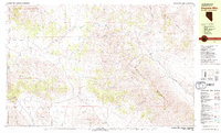
1979 Map of Dogskin Mtn
USGS Topo · Published 1979About this map
Winnemucca Ranch serves as a lone human outpost in this high-desert landscape, situated where the Winnemucca Valley meets the slopes of Dogskin Mountain. The topography is defined by complex drainage networks, with the North Fork and South Fork of Dry Valley Creek carving through the arid terrain. This 1970s survey captures a wilderness interface where small-scale mining activity is evident through various prospects scattered near the Fort Sage Mountains. Water remains the most critical resource for the region's ranching and transit, marked by a high density of named water sources such as Lower Wildcat Spring, Upper Wildcat Spring, and Miller Spring. The map also traces the California-Nevada border as it intersects the Dry Valley, providing a detailed look at the interstate boundary before it climbs toward Petersen Mountain.
Find a feature on this map
49 named features on this map. Tap any name to fly to it.
Don’t see what you’re looking for? This feature index may not catch every label — zoom into the map to look around manually.
Map Details
Editions of this 1979 Dogskin Mtn Map
3 editions found
Other maps of this area

1886 · Honey Lake
USGS Topo · 1:250,000

1886 · Granite Range
USGS Topo · 1:250,000

1890 · Sierraville
USGS Topo · 1:125,000

1891 · Honey Lake
USGS Topo · 1:250,000

1891 · Reno
USGS Topo · 1:125,000

1892 · Sierraville
USGS Topo · 1:125,000

1893 · Honey Lake
USGS Topo · 1:250,000

1893 · Reno
USGS Topo · 1:125,000

1894 · Granite Range
USGS Topo · 1:250,000

1894 · Sierraville
USGS Topo · 1:125,000