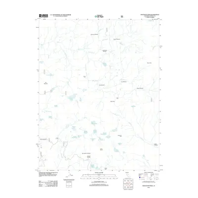
2012 Map of Dogtooth Peak
USGS Topo · Published 2012About this map
Dogtooth Peak and the surrounding high-altitude wilderness of Fresno County are defined by a dense network of glacial lakes and meadows. This 2012 survey shows the intricate drainage systems of Big Cr and Dinkey Cr, which feed numerous bodies of water including Coyote Lake, Mirror Lake, and the First Dinkey Lake chain. The landscape is dotted with established outposts such as Perkins Camp and Qualls Camp, reflecting the area's history as a destination for backcountry exploration.
Find a feature on this map
60 named features on this map. Tap any name to fly to it.
Don’t see what you’re looking for? This feature index may not catch every label — zoom into the map to look around manually.
Map Details
Editions of this 2012 Dogtooth Peak Map
This is the sole edition of this map. No revisions or reprints were ever made.
Other maps of this area

1904 · Kaiser
USGS Topo · 1:125,000

1912 · Mt. Goddard
USGS Topo · 1:125,000

1947 · Mariposa
USGS Topo · 1:250,000

1948 · Mariposa
USGS Topo · 1:250,000

1953 · Mt Abbot
USGS Topo · 1:62,500

1953 · Huntington Lake
USGS Topo · 1:62,500

1953 · Blackcap Mtn
USGS Topo · 1:62,500

1953 · Kaiser Peak
USGS Topo · 1:62,500

1957 · Mariposa
USGS Topo · 1:250,000
1962 · Blackcap Mtn
USGS Topo · 1:62,500