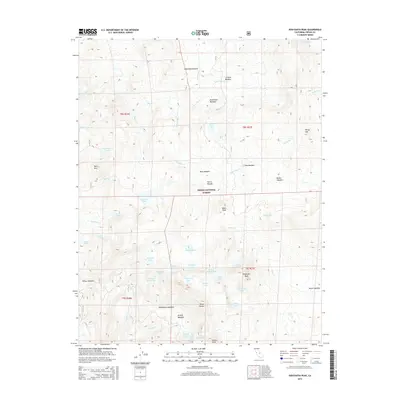
2015 Map of Dogtooth Peak
USGS Topo · Published 2015About this map
Sierra National Forest encompasses this high-elevation landscape in the Sierra Nevada, where a dense network of glacial basins and alpine meadows defines the terrain. The presence of Miningtown Meadow suggests early human activity and resource extraction in the high country, positioned between Three Sisters and Dogtooth Peak. The drainage patterns are complex, with waters flowing through Dinkey Cr and Helms Cr, connecting a vast series of named water bodies including First Dinkey Lake, Second Dinkey Lake, and the remote Crater Lake at the northern boundary. Dozens of meadows like Ershim Meadow and Rockhouse Meadow break the timberline, providing evidence of the seasonal grazing and exploration that shaped this portion of Fresno County. From the sharp ascent at Windy Gap to the quiet waters of Mirror Lake, the map documents a geography of granite and water preserved for conservation and recreation.
Find a feature on this map
57 named features on this map. Tap any name to fly to it.
Don’t see what you’re looking for? This feature index may not catch every label — zoom into the map to look around manually.
Map Details
Editions of this 2015 Dogtooth Peak Map
This is the sole edition of this map. No revisions or reprints were ever made.
Other maps of this area

1904 · Kaiser
USGS Topo · 1:125,000

1912 · Mt. Goddard
USGS Topo · 1:125,000

1947 · Mariposa
USGS Topo · 1:250,000

1948 · Mariposa
USGS Topo · 1:250,000

1953 · Mt Abbot
USGS Topo · 1:62,500

1953 · Huntington Lake
USGS Topo · 1:62,500

1953 · Blackcap Mtn
USGS Topo · 1:62,500

1953 · Kaiser Peak
USGS Topo · 1:62,500

1957 · Mariposa
USGS Topo · 1:250,000
1962 · Blackcap Mtn
USGS Topo · 1:62,500