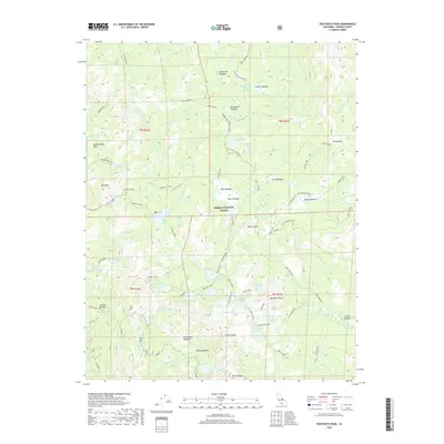
2018 Map of Dogtooth Peak
USGS Topo · Published 2018About this map
Sierra National Forest encompasses this high-elevation landscape within the Sierra Nevada, characterized by a dense concentration of glacial lakes and meadows. The area's history of human activity is marked by Miningtown Meadow, while its more contemporary use for recreation is defined by the Dusy-Ershim OHV Route and the Perkins Cutoff. Prominent landmarks like Dogtooth Peak, Bartholomew Peak, and Chinese Peak anchor the terrain, providing fixed points for navigating the complex hydrography. The map details a sophisticated network of waterways including Dinkey Cr and Helms Cr, which feed into numerous distinct alpine pools such as Fingerbowl Lake, Bullfrog Lake, and the Dinkey Lakes cluster. These water sources are interspersed with expansive clearings like Rockhouse Meadow and Rodeo Meadow, suggesting the long-standing ecological and commercial value of these mountain pastures.
Find a feature on this map
77 named features on this map. Tap any name to fly to it.
Don’t see what you’re looking for? This feature index may not catch every label — zoom into the map to look around manually.
Map Details
Editions of this 2018 Dogtooth Peak Map
This is the sole edition of this map. No revisions or reprints were ever made.
Other maps of this area

1904 · Kaiser
USGS Topo · 1:125,000

1912 · Mt. Goddard
USGS Topo · 1:125,000

1947 · Mariposa
USGS Topo · 1:250,000

1948 · Mariposa
USGS Topo · 1:250,000

1953 · Mt Abbot
USGS Topo · 1:62,500

1953 · Huntington Lake
USGS Topo · 1:62,500

1953 · Blackcap Mtn
USGS Topo · 1:62,500

1953 · Kaiser Peak
USGS Topo · 1:62,500

1957 · Mariposa
USGS Topo · 1:250,000
1962 · Blackcap Mtn
USGS Topo · 1:62,500