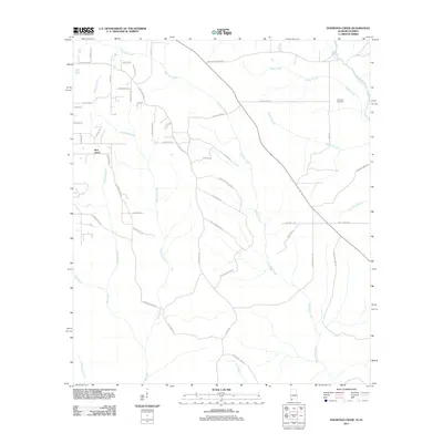
2011 Map of Dogwood Creek
USGS Topo · Published 2011About this map
Pine Grove and the surrounding rural landscapes of Baldwin County are defined by an intricate network of waterways draining toward the Perdido River and the Styx River. This 2011 survey captures a region characterized by timberlands and small-scale agriculture, where the land is carved by Hollinger Creek, Dogwood Creek, and numerous smaller tributaries like Dodds Branch. The map reveals a high density of rural roads and family-named routes, such as Old Brady Rd, Old Davison Rd, and Lonnie Paul Rd, reflecting a lineage of land ownership and local settlement patterns. Genealogical interest is anchored by the High Pine Cemetery in the northeast, positioned between the headwaters of Indian Creek and the river. The layout of these roads and property access points provides a clear record of the area's development before more modern suburban expansion influenced this part of Alabama.
Find a feature on this map
52 named features on this map. Tap any name to fly to it.
Don’t see what you’re looking for? This feature index may not catch every label — zoom into the map to look around manually.
Map Details
Editions of this 2011 Dogwood Creek Map
This is the sole edition of this map. No revisions or reprints were ever made.
Other maps of this area

1920 · Robertsdale
USGS Topo · 1:62,500

1921 · Fairhope
USGS Topo · 1:62,500

1941 · Bay Minette
USGS Topo · 1:62,500

1941 · Robertsdale
USGS Topo · 1:62,500

1941 · Fairhope
USGS Topo · 1:62,500

1942 · Dyas
USGS Topo · 1:62,500

1943 · Robertsdale
USGS Topo · 1:62,500

1943 · Bay Minette
USGS Topo · 1:62,500
1943 · Fairhope
USGS Topo · 1:62,500
1944 · Stapleton
USGS Topo · 1:31,680