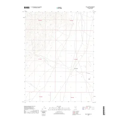
2018 Map of Dolly Varden
USGS Topo · Published 2018About this map
Dolly Varden is the central point of interest in this high-desert Elko County landscape, where the flat expanse of the Goshute Valley meets the rising terrain to the west. The area's water sources, including Indian Cr and Nelson Cr, are critical landmarks in this arid environment, defining the drainage patterns through the southern sections of the quadrangle. A network of unimproved roads and the prominent Dolly Varden Spring Rd connect these remote points, reflecting a land use focused on resource access and high-clearance navigation. This survey documents the intersection of several townships, including t31n r65e and t31n r66e, providing a clear view of the cadastral boundaries that organize this part of the Great Basin.
Find a feature on this map
11 named features on this map. Tap any name to fly to it.
Don’t see what you’re looking for? This feature index may not catch every label — zoom into the map to look around manually.
Map Details
Editions of this 2018 Dolly Varden Map
This is the sole edition of this map. No revisions or reprints were ever made.
Other maps of this area

1953 · Spruce Mountain 4
USGS Topo · 1:62,500

1955 · Elko
USGS Topo · 1:250,000

1958 · Elko
USGS Topo · 1:250,000

1962 · Elko
USGS Topo · 1:250,000

1965 · Elko
USGS Topo · 1:250,000

1971 · Decoy
USGS Topo · 1:24,000

1972 · Decoy SW
USGS Topo · 1:24,000
1982 · White Horse Mountain NW
USGS Topo · 1:24,000

1982 · Mizpah
USGS Topo · 1:24,000
1982 · Mizpah Point
USGS Topo · 1:24,000