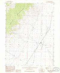
1986 Map of Dolly Varden
USGS Topo · Published 1986About this map
The Pequop Mountains dominate the western horizon of this high-desert landscape, their steep slopes giving way to the expansive floor of the Goshute Valley. The settlement at Dolly Varden sits at a critical junction of routes through the basin, representing a remote outpost in eastern Elko County during the mid-1980s. This survey records a network of ephemeral watercourses and resource extraction sites, including drainage from Indian Creek and Nelson Creek which flow toward the valley floor. Evidence of mineral exploration is present near the mountain foothills, where a Prospect is noted alongside numerous 4wd tracks. The map captures a moment when the region remained largely undeveloped, defined by its traditional ranching and mining character and the vast distances between named landmarks.
Find a feature on this map
9 named features on this map. Tap any name to fly to it.
Don’t see what you’re looking for? This feature index may not catch every label — zoom into the map to look around manually.
Map Details
Editions of this 1986 Dolly Varden Map
This is the sole edition of this map. No revisions or reprints were ever made.
Other maps of this area

1953 · Spruce Mountain 4
USGS Topo · 1:62,500

1955 · Elko
USGS Topo · 1:250,000

1958 · Elko
USGS Topo · 1:250,000

1962 · Elko
USGS Topo · 1:250,000

1965 · Elko
USGS Topo · 1:250,000

1971 · Decoy
USGS Topo · 1:24,000

1972 · Decoy SW
USGS Topo · 1:24,000
1982 · White Horse Mountain NW
USGS Topo · 1:24,000

1982 · Mizpah
USGS Topo · 1:24,000
1982 · Mizpah Point
USGS Topo · 1:24,000