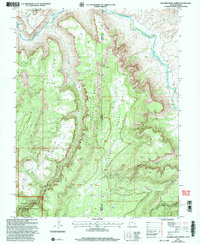
2001 Map of Dolores Point North
USGS Topo · Published 2004About this map
The Dolores River winds through the high desert plateaus of the Utah-Colorado border, creating a landscape of deep canyons and isolated mesas. This survey, revised at the beginning of the 21st century, illustrates the complex topography where Polar Mesa and Beaver Mesa rise above the river valley. The map documents numerous mines scattered across the upland flats, particularly near Dolores Point and the head of Getaway Canyon, indicating a history of mineral exploration in this remote corner of the Manti-La Sal National Forest.
Find a feature on this map
30 named features on this map. Tap any name to fly to it.
Don’t see what you’re looking for? This feature index may not catch every label — zoom into the map to look around manually.
Map Details
Editions of this 2001 Dolores Point North Map
This is the sole edition of this map. No revisions or reprints were ever made.
Other maps of this area

1885 · La Sal
USGS Topo · 1:250,000

1949 · Juanita Arch
USGS Topo · 1:24,000

1949 · Gateway
USGS Topo · 1:24,000

1950 · Juanita Arch
USGS Topo · 1:24,000

1952 · Gateway
USGS Topo · 1:24,000

1954 · Mt. Waas 4 SE
USGS Topo · 1:24,000

1954 · Mt. Waas 4 SW
USGS Topo · 1:24,000

1954 · Mt. Waas 4 NE
USGS Topo · 1:24,000

1954 · Mt. Waas 4 NW
USGS Topo · 1:24,000

1954 · Mt. Waas 1 SW
USGS Topo · 1:24,000