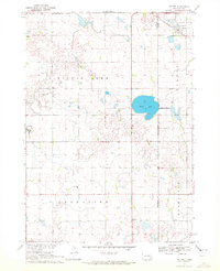
1970 Map of Dolton
USGS Topo · Published 1972About this map
Silver Lake serves as a central landmark for this rural landscape where the boundaries of McCook, Hutchinson, and Turner counties meet. During the late 1960s, this area was characterized by a high density of small-scale religious and community sites, reflecting the strong heritage of local Hutterite and Mennonite settlements. The map identifies specific denominational and family markers such as Hutterthal Ch and Silver Lake Ch, alongside family-named burial grounds like Schartner Cem and Kleinsasser Cem. The town of Dolton anchors the northern portion of the quadrangle, while the southern reaches are marked by the presence of the C M St P & P railroad. This survey provides a precise record of section-line roads and field boundaries as they existed before the significant consolidation of many Midwestern family farms.
Find a feature on this map
17 named features on this map. Tap any name to fly to it.
Don’t see what you’re looking for? This feature index may not catch every label — zoom into the map to look around manually.
Map Details
Editions of this 1970 Dolton Map
This is the sole edition of this map. No revisions or reprints were ever made.
Other maps of this area

1898 · Olivet
USGS Topo · 1:125,000

1898 · Parker
USGS Topo · 1:125,000

1899 · Alexandria
USGS Topo · 1:125,000

1955 · Sioux Falls
USGS Topo · 1:250,000

1957 · Wolf Creek
USGS Topo · 1:24,000

1958 · Sioux Falls
USGS Topo · 1:250,000

1964 · Canistota
USGS Topo · 1:24,000

1964 · Bridgewater East
USGS Topo · 1:24,000

1970 · Clayton NE
USGS Topo · 1:24,000

1970 · Freeman SE
USGS Topo · 1:24,000
Featured Places
- Dolton, SD
- Grandview Township, SD
- Rosefield Township, SD
- Bridgewater Township, SD
- Silver Lake Township, SD