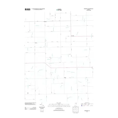
2013 Map of Domestic
USGS Topo · Published 2013About this map
Domestic and Perryville anchor this rural landscape in Adams County, Indiana, where an extensive network of drainage ditches and creeks defines the agricultural character of the region. The map documents a highly structured township-and-range system, with roads such as W 900 S and W 800 N following rigid cardinal lines. This grid is frequently interrupted by the winding paths of natural waterways like Loblolly Cr and Threemile Cr, and human-engineered improvements such as the Bourne-Williams Ditch and Egley Ditch.
Find a feature on this map
91 named features on this map. Tap any name to fly to it.
Don’t see what you’re looking for? This feature index may not catch every label — zoom into the map to look around manually.
Map Details
Editions of this 2013 Domestic Map
This is the sole edition of this map. No revisions or reprints were ever made.
Other maps of this area

1911 · Berne
USGS Topo · 1:48,000

1915 · Fort Recovery
USGS Topo · 1:48,000

1918 · Fort Recovery
USGS Topo · 1:62,500

1953 · Muncie
USGS Topo · 1:250,000

1956 · Muncie
USGS Topo · 1:250,000

1960 · Pennville
USGS Topo · 1:24,000

1960 · Blaine
USGS Topo · 1:24,000
1960 · Portland
USGS Topo · 1:24,000

1962 · Berne
USGS Topo · 1:24,000

1962 · Petroleum
USGS Topo · 1:24,000