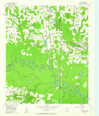
1954 Map of Domino
USGS Topo · Published 1963About this map
The Sulphur River meanders through a landscape defined by the convergence of Texas and Arkansas state lines and multiple county boundaries. In the mid-1950s, this region was a corridor for heavy industrial transport, with both the Texas and Pacific and the Kansas City Southern railroads bisecting the terrain. The presence of the Federal Correctional Institution and numerous active gravel extraction sites, including the Gifford Hill Gravel Pit and several Strip Mines, highlights an area driven by institutional infrastructure and resource industry.
Find a feature on this map
55 named features on this map. Tap any name to fly to it.
Don’t see what you’re looking for? This feature index may not catch every label — zoom into the map to look around manually.
Map Details
Editions of this 1954 Domino Map
5 editions found
Other maps of this area

1907 · Atlanta
USGS Topo · 1:62,500

1909 · Texarkana
USGS Topo · 1:62,500

1910 · Atlanta
USGS Topo · 1:62,500

1952 · Mandeville
USGS Topo · 1:24,000

1952 · Doddridge NW
USGS Topo · 1:24,000

1952 · Fouke
USGS Topo · 1:24,000

1953 · Texarkana
USGS Topo · 1:250,000

1953 · El Dorado
USGS Topo · 1:250,000

1954 · Texarkana
USGS Topo · 1:24,000

1954 · Domino
USGS Topo · 1:24,000