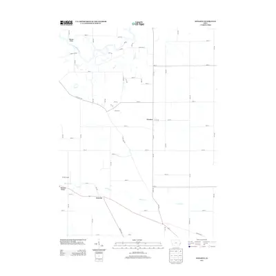
2013 Map of Donahue
USGS Topo · Published 2013About this map
The Wapsipinicon River defines the northern boundary of this landscape, winding through a network of small creeks and rural intersections. This survey captures a moment in the early 21st century when the agrarian character of Scott County remained preserved through scattered settlements like Donahue and Maysville. The terrain is marked by the branching paths of Mud Cr and Hickory Cr, which dictate the placement of local thoroughfares such as Allens Grove Rd and River Camp Rd. Smaller community nodes like Buena Vista and Allens Grove appear as quiet junctions in the grid of Iowa farm roads. Aviation history is noted by the presence of Stender Airport in the western portion of the map, while the southern reaches transition toward the edges of Hickory Grove, highlighting the region's blend of natural drainage basins and organized township development.
Find a feature on this map
59 named features on this map. Tap any name to fly to it.
Don’t see what you’re looking for? This feature index may not catch every label — zoom into the map to look around manually.
Map Details
Editions of this 2013 Donahue Map
This is the sole edition of this map. No revisions or reprints were ever made.
Other maps of this area

1890 · Durant
USGS Topo · 1:62,500

1891 · DeWitt
USGS Topo · 1:62,500

1891 · Davenport
USGS Topo · 1:62,500

1892 · Wheatland
USGS Topo · 1:62,500

1894 · Wheatland
USGS Topo · 1:62,500

1894 · Durant
USGS Topo · 1:62,500

1894 · Davenport
USGS Topo · 1:62,500

1901 · Rock Island
USGS Topo · 1:125,000

1910 · Rock Island
USGS Topo · 1:125,000
1949 · Davenport
USGS Topo · 1:24,000