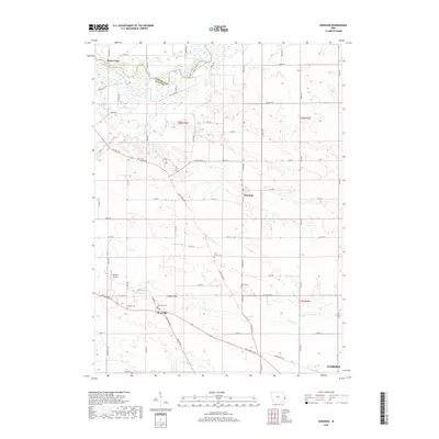
2018 Map of Donahue
USGS Topo · Published 2018About this map
Wapsipinicon River meanders across the northern border of Scott County, defining the boundary with Clinton County. This rural landscape is anchored by the small incorporations of Donahue and Maysville, connected by a grid of section roads and Allens Grove Rd. The agricultural character of the region is punctuated by numerous family and community burial grounds, including Allens Grove Cem and Linn Grove Cem, which serve as vital markers for local genealogical research. In the southwest, Stender Airport sits near the headwaters of Hickory Cr, while the northwestern corner features the riverfront settlement of Buena Vista. The edge of Eldridge appears in the southeast, showing the expansion of residential development toward the rural townships. Drainage patterns from Mud Cr and Hickory Creek illustrate the varied topography that has influenced farm placement and road networks for generations.
Find a feature on this map
61 named features on this map. Tap any name to fly to it.
Don’t see what you’re looking for? This feature index may not catch every label — zoom into the map to look around manually.
Map Details
Editions of this 2018 Donahue Map
This is the sole edition of this map. No revisions or reprints were ever made.
Other maps of this area

1890 · Durant
USGS Topo · 1:62,500

1891 · DeWitt
USGS Topo · 1:62,500

1891 · Davenport
USGS Topo · 1:62,500

1892 · Wheatland
USGS Topo · 1:62,500

1894 · Wheatland
USGS Topo · 1:62,500

1894 · Durant
USGS Topo · 1:62,500

1894 · Davenport
USGS Topo · 1:62,500

1901 · Rock Island
USGS Topo · 1:125,000

1910 · Rock Island
USGS Topo · 1:125,000
1949 · Davenport
USGS Topo · 1:24,000