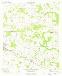
1974 Map of Donalsonville East
USGS Topo · Published 1976About this map
Iron City and the eastern edge of Donalsonville anchor this mid-1970s survey of the Georgia coastal plain. The landscape is defined by a dense network of country churches and family burial grounds, reflecting the deep-rooted agricultural communities across the Seminole County line. Travelers and residents alike were served by the Seaboard Coast Line railroad, which parallels Highway 84 through the small settlement of Sharphagen. The presence of numerous small churches such as New Home Ch, Union Ch, and Pleasant Hill Ch suggests a rural society built around local congregations. Natural drainage is provided by the winding courses of Aycocks Creek and Dry Creek, while the Donalsonville Municipal Airport and a prominent Pipeline indicate the modernization of the local infrastructure during this era.
Find a feature on this map
28 named features on this map. Tap any name to fly to it.
Don’t see what you’re looking for? This feature index may not catch every label — zoom into the map to look around manually.
Map Details
Editions of this 1974 Donalsonville East Map
This is the sole edition of this map. No revisions or reprints were ever made.
Other maps of this area

1953 · Dothan
USGS Topo · 1:250,000

1954 · Dothan
USGS Topo · 1:250,000

1954 · Steam Mill
USGS Topo · 1:24,000

1954 · Desser
USGS Topo · 1:24,000

1954 · Tallahassee
USGS Topo · 1:250,000

1955 · Dothan
USGS Topo · 1:250,000

1955 · Bainbridge
USGS Topo · 1:62,500

1959 · Tallahassee
USGS Topo · 1:250,000

1960 · Tallahassee
USGS Topo · 1:250,000

1974 · Boykin
USGS Topo · 1:24,000