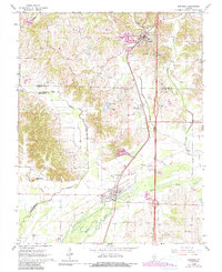
1966 Map of Dongola
USGS Topo · Published 1990About this map
Dongola and Ullin anchor this mid-century survey of Southern Illinois, situated along the north-south corridor of the Illinois Central Railroad. The landscape is defined by the winding course of the Cache River and its numerous tributaries, including Indian Camp Creek and Butter Ridge Creek. The survey reveals a rural society organized around small communities and family landmarks, with Mt Pisgah Ch and Beech Grove Ch serving as local focal points alongside several well-placed burial grounds like Sheffer Cem and Union Cem.
Find a feature on this map
31 named features on this map. Tap any name to fly to it.
Don’t see what you’re looking for? This feature index may not catch every label — zoom into the map to look around manually.
Map Details
Editions of this 1966 Dongola Map
3 editions found
Other maps of this area

1920 · Jonesboro
USGS Topo · 1:62,500

1920 · Dongola
USGS Topo · 1:62,500

1923 · Dongola
USGS Topo · 1:62,500

1923 · Jonesboro
USGS Topo · 1:62,500

1931 · Cairo
USGS Topo · 1:62,500

1933 · Cairo
USGS Topo · 1:62,500

1934 · Thebes
USGS Topo · 1:62,500

1939 · Cairo
USGS Topo · 1:62,500

1939 · Thebes
USGS Topo · 1:62,500

1947 · Jonesboro
USGS Topo · 1:62,500