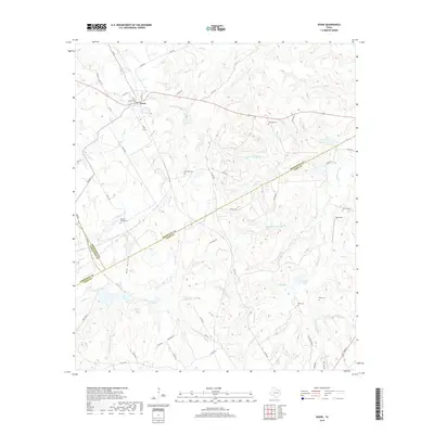
2019 Map of Donie
USGS Topo · Published 2019About this map
Donie serves as the primary settlement in this landscape defined by the converging borders of Freestone, Leon, and Limestone counties. The area is characterized by a dense network of seasonal and perennial watercourses, including Buffalo Cr and Alum Br, which drain toward the Donie Reservoir. Rural life is centered around a collection of historic burial grounds such as Old Zion Cem, Post Oak Cem, and Wilsons Chapel Cem, serving as focal points for local genealogy. The presence of Gas Well Rd and Mine Road 9 suggests a landscape shaped by resource extraction alongside traditional land use. In the southeastern portion, the terrain shifts toward unique wetlands like Alligator Pond and Flag Pond, while Hub Field represents a localized point of aviation activity amidst the creek branches.
Find a feature on this map
70 named features on this map. Tap any name to fly to it.
Don’t see what you’re looking for? This feature index may not catch every label — zoom into the map to look around manually.
Map Details
Editions of this 2019 Donie Map
This is the sole edition of this map. No revisions or reprints were ever made.
Other maps of this area

1919 · Fairfield
USGS Topo · 1:62,500

1920 · Mexia
USGS Topo · 1:62,500

1954 · Waco
USGS Topo · 1:250,000

1955 · Waco
USGS Topo · 1:250,000

1956 · Jewett
USGS Topo · 1:62,500

1965 · Jewett
USGS Topo · 1:24,000
1965 · Robbins
USGS Topo · 1:24,000

1965 · Dew
USGS Topo · 1:24,000
1965 · Lanely
USGS Topo · 1:24,000
1965 · Buffalo
USGS Topo · 1:24,000