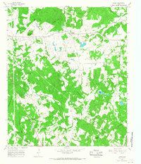
1965 Map of Lanely
USGS Topo · Published 1967About this map
Lanely serves as the central hub of this mid-1960s survey along the border of Freestone and Leon Counties. The landscape is defined by the headwaters of several drainage systems, including Upper Keechi Creek, Folsom Creek, and Whitney Creek, which carve through the Folsom Hills. This era shows a rural Texas community structured around small country churches and cemeteries, such as Harrison Chapel Cem and Mt Pleasant Ch. An interesting industrial footprint is visible through several pipelines and a Gas Well situated west of Lanely. The inclusion of Marshy Springs and Chandler Bottom indicates the low-lying, poorly drained areas that contrasted with the more elevated terrain of Burleson Hill, providing a detailed look at the agricultural and geophysical boundaries of the region before significant modern development.
Find a feature on this map
27 named features on this map. Tap any name to fly to it.
Don’t see what you’re looking for? This feature index may not catch every label — zoom into the map to look around manually.
Map Details
Editions of this 1965 Lanely Map
2 editions found
Other maps of this area

1919 · Fairfield
USGS Topo · 1:62,500

1953 · Palestine
USGS Topo · 1:250,000

1954 · Waco
USGS Topo · 1:250,000

1955 · Waco
USGS Topo · 1:250,000

1956 · Jewett
USGS Topo · 1:62,500

1957 · Palestine
USGS Topo · 1:250,000

1964 · Flo
USGS Topo · 1:24,000

1964 · Keechi
USGS Topo · 1:24,000
1964 · Butler
USGS Topo · 1:24,000

1965 · Dew
USGS Topo · 1:24,000