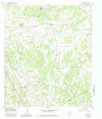
1965 Map of Lanely
USGS Topo · Published 1983About this map
Lanely and Concord anchor this rural landscape in Freestone County, documented during the mid-1960s with updates reflecting the late 1970s. The terrain is defined by a dense network of tributaries including Self Creek, Browns Creek, and Dottie Branch, which feed into the broad Chandler Bottom. This topography reveals a scatter of community hubs centered on small country churches and burial grounds, such as Mt Pleasant Ch and Harrison Chapel Cem.
Find a feature on this map
32 named features on this map. Tap any name to fly to it.
Don’t see what you’re looking for? This feature index may not catch every label — zoom into the map to look around manually.
Map Details
Editions of this 1965 Lanely Map
2 editions found
Other maps of this area

1919 · Fairfield
USGS Topo · 1:62,500

1953 · Palestine
USGS Topo · 1:250,000

1954 · Waco
USGS Topo · 1:250,000

1955 · Waco
USGS Topo · 1:250,000

1956 · Jewett
USGS Topo · 1:62,500

1957 · Palestine
USGS Topo · 1:250,000

1964 · Flo
USGS Topo · 1:24,000

1964 · Keechi
USGS Topo · 1:24,000
1964 · Butler
USGS Topo · 1:24,000

1965 · Dew
USGS Topo · 1:24,000