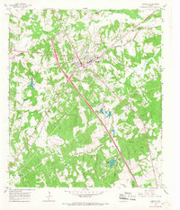
1965 Map of Buffalo
USGS Topo · Published 1967About this map
Buffalo serves as the central hub of this mid-1960s survey, situated where major roadways intersect and the Missouri Pacific railroad cuts a diagonal line through the landscape. The town’s infrastructure is documented in detail, featuring the Jr High Sch, an Athletic Field, and the County Hosp. Beyond the town limits, the terrain is defined by a dense network of creeks, including Buffalo Creek, Cedar Creek, and Bliss Creek, which drain the wooded hills of the Freestone Co and Leon Co border region.
Find a feature on this map
38 named features on this map. Tap any name to fly to it.
Don’t see what you’re looking for? This feature index may not catch every label — zoom into the map to look around manually.
Map Details
Editions of this 1965 Buffalo Map
2 editions found
Other maps of this area

1919 · Fairfield
USGS Topo · 1:62,500

1953 · Palestine
USGS Topo · 1:250,000

1954 · Waco
USGS Topo · 1:250,000

1955 · Waco
USGS Topo · 1:250,000

1956 · Jewett
USGS Topo · 1:62,500

1957 · Palestine
USGS Topo · 1:250,000

1964 · Centerville
USGS Topo · 1:24,000

1964 · Flo
USGS Topo · 1:24,000

1964 · Keechi
USGS Topo · 1:24,000

1965 · Jewett
USGS Topo · 1:24,000