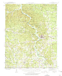
1939 Map of Doniphan
USGS Topo · Published 1975About this map
Doniphan serves as the focal point of this pre-war survey, situated along the banks of the Current River where the Missouri Pacific railroad line terminates. The landscape is characterized by a high density of rural schools and family-named landmarks, reflecting a well-established river-valley community before the mid-century shifts in rural population. Dozens of one-room schoolhouses such as Barkadaro Sch, Ponder Sch, and Sugar Tree Sch dot the hills, while social hubs like Dudleys Club and Skipper-Johnson Club appear along the river.
Find a feature on this map
127 named features on this map. Tap any name to fly to it.
Don’t see what you’re looking for? This feature index may not catch every label — zoom into the map to look around manually.
Map Details
Editions of this 1939 Doniphan Map
3 editions found
Other maps of this area

1934 · Williamsville
USGS Topo · 1:48,000

1935 · Acorn
USGS Topo · 1:62,500

1935 · Knobel
USGS Topo · 1:62,500

1935 · Reyno
USGS Topo · 1:62,500

1939 · Doniphan
USGS Topo · 1:62,500

1940 · Williamsville
USGS Topo · 1:62,500

1940 · Naylor
USGS Topo · 1:62,500

1941 · Gatewood
USGS Topo · 1:62,500

1941 · Knobel
USGS Topo · 1:62,500

1944 · Naylor
USGS Topo · 1:62,500