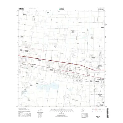
2016 Map of Donna
USGS Topo · Published 2016About this map
The dense network of residential colonias and urban expansions defines this portion of the Rio Grande Valley, where the cities of Donna, Alamo, and Weslaco are linked by a complex grid of roads and highways. This survey illustrates the intricate settlement patterns of the region, from established neighborhoods near Saint Joseph Cem to dozens of named residential clusters like Villa Donna Colonia and Midway Village Colonia. The landscape is critically managed by water infrastructure, dominated by the Main Floodway in the south and the twin basins of Donna Reservoir 1 and Donna Reservoir 2. These features, alongside the numerous mile-roads and drainage patterns, reveal the transformation of agricultural land into a burgeoning suburban corridor. The map serves as a detailed record of local genealogy and land development, naming smaller settlements such as Scissors, Muniz, and South Alamo that fill the spaces between the larger municipal centers.
Find a feature on this map
255 named features on this map. Tap any name to fly to it.
Don’t see what you’re looking for? This feature index may not catch every label — zoom into the map to look around manually.
Map Details
Editions of this 2016 Donna Map
This is the sole edition of this map. No revisions or reprints were ever made.
Other maps of this area

1914 · San Juan
USGS Topo · 1:48,000

1916 · San Juan
USGS Topo · 1:62,500

1949 · Mc Allen
USGS Topo · 1:250,000

1953 · Brownsville
USGS Topo · 1:250,000

1954 · McAllen
USGS Topo · 1:250,000

1956 · Mercedes
USGS Topo · 1:24,000
1956 · Progreso
USGS Topo · 1:24,000

1956 · Brownsville
USGS Topo · 1:250,000

1956 · Port Isabel
USGS Topo · 1:250,000
1957 · Edcouch
USGS Topo · 1:24,000